
The Budhi Gandaki Valley is one of the most remarkable river valleys in central Nepal, stretching from the high Himalayan settlements near Samdo and Sama Gaon in the Manaslu region down to the lower hills and river confluence at Benighat. This valley forms a natural corridor between the towering Himalayas and the subtropical lowlands, carved over thousands of years by the powerful Budhi Gandaki River. Originating in the high Himalayan region north of Mount Manaslu, the river flows southward for about 130 kilometers before meeting the Trishuli River at Benighat, creating one of the significant river junctions in central Nepal.
The Upper Budhi Gandaki Valley: Samdo and the High Himalayan Landscape
The journey through the Budhi Gandaki Valley begins in the remote high-altitude village of Samdo, located at an elevation of about 3,860 meters in the Manaslu region. Samdo lies close to the Tibetan border and is surrounded by dramatic Himalayan peaks, including Mount Manaslu (8,163 m), the eighth highest mountain in the world. The upper valley here is wide, open, and shaped by ancient glaciers, with barren slopes, alpine grasslands, and scattered yak pastures.
In this high Himalayan environment, the Budhi Gandaki River begins as a cold, fast-flowing glacial stream fed by melting snow and glaciers from the Manaslu range. The river’s waters are crystal clear and extremely cold, carrying sediments and minerals eroded from the surrounding mountains. Small tributaries descend from steep slopes and join the main river, increasing its volume as it flows south.
The villages in this region, such as Samdo and nearby Sama Gaon, are deeply influenced by Tibetan culture. Stone houses, Buddhist monasteries, mani walls, and prayer flags reflect centuries of Himalayan traditions.
Table of Contents
Local people rely on yak herding, small agriculture, and trade routes historically connected with Tibet. The Budhi Gandaki River has always played a vital role here, providing water, fertile land for crops, and a natural route through the rugged terrain.
Descending Through the Middle Valley: Forests, Villages, and Deep Gorges
As the river continues south from Sama Gaon and Samdo, the valley gradually narrows and descends into the middle hills of the Manaslu region. The landscape transforms dramatically as altitude decreases. Alpine terrain slowly gives way to lush forests of pine, rhododendron, bamboo, and oak.
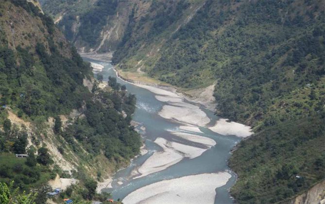
In this middle section, the Budhi Gandaki River becomes more powerful and turbulent. The river flows through steep gorges, carving dramatic cliffs and rocky canyons. The trekking trails that follow the Manaslu Circuit frequently cross suspension bridges that span the roaring river below. These bridges connect remote villages such as Jagat, Deng, Namrung, and Philim, each of which has its own unique cultural identity and traditional lifestyle.
The Budhi Gandaki Valley in this section is also rich in biodiversity. The surrounding forests are part of the Manaslu Conservation Area, which protects many rare Himalayan species. Wildlife such as Himalayan tahr, musk deer, red panda, and numerous bird species inhabit these forests. The river and its tributaries also support aquatic life and serve as an essential water source for local communities.
Agriculture becomes more common as the valley descends. Terraced fields of maize, millet, barley, and potatoes appear along the hillsides, and villages are often built on elevated terraces above the river to protect them from seasonal floods.
The Lower Budhi Gandaki Valley: From Arughat to the Hills of Dhading and Gorkha
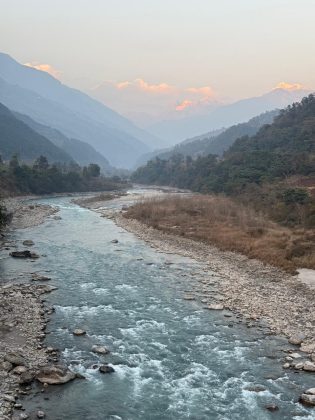
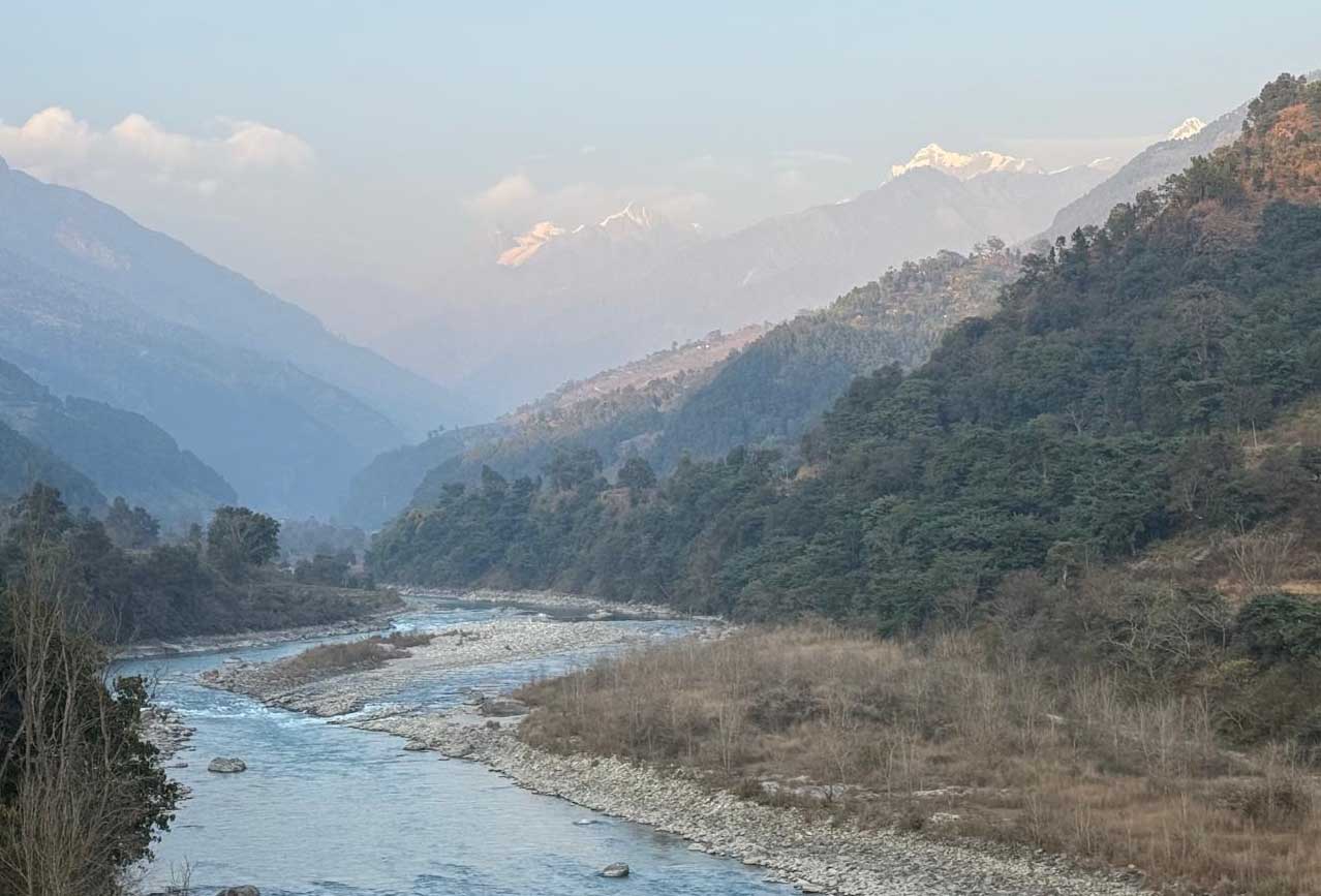
Further downstream, the valley widens and the climate becomes warmer. After passing settlements like Machha Khola, Soti Khola, and Arughat, the Budhi Gandaki enters the lower hills of Gorkha and Dhading districts. Here the river becomes broader and calmer compared to the steep upper sections.
The valley in this region is characterized by green hills, subtropical forests, and fertile agricultural land. Farmers cultivate rice, maize, vegetables, and fruits along the riverbanks and terraces. The river provides irrigation water that sustains local agriculture and rural livelihoods.
Historically, the Budhi Gandaki Valley served as an important travel and trade route linking the high Himalayas with the lower regions of Nepal. People from different ethnic communities including Gurung, Tamang, and Brahmin-Chhetri groups have settled along the valley, creating a rich cultural mosaic. Traditional houses, local temples, and vibrant village life are common sights along the river corridor.
The river also forms a natural boundary between the Gorkha and Dhading districts in its lower sections. As it continues southward, the Budhi Gandaki gathers water from numerous tributaries, increasing its strength and volume.
Hydrological Importance of the Budhi Gandaki River
The Budhi Gandaki River is an important tributary within the larger Gandaki River system of Nepal. It originates in the Himalayan region north of Manaslu and flows southward to join the Trishuli River near Benighat. From there, the combined waters eventually become part of the Narayani River, one of Nepal’s major river systems that ultimately flows into the Ganges basin.
Because of its strong flow and steep gradient, the Budhi Gandaki River has enormous hydropower potential. The Government of Nepal has proposed the Budhi Gandaki Hydropower Project, one of the largest planned storage hydropower projects in the country. The dam site is located a few kilometers upstream from the confluence with the Trishuli River near Benighat.
This project aims to generate significant electricity and help stabilize Nepal’s energy supply, particularly during the dry season when river flows are lower.
The Final Section: Benighat and the Confluence with the Trishuli River
The Budhi Gandaki Valley ultimately reaches its end at Benighat, where the Budhi Gandaki River merges with the Trishuli River. This confluence lies at an elevation of approximately 478 meters above sea level, marking the transition from the hilly region to the broader river systems of central Nepal. This part is nice for White water Rafting
Benighat is located along the Prithvi Highway, the major road connecting Kathmandu and Pokhara. This location makes the confluence easily accessible and an important transportation hub. Travelers driving along the highway can see the dramatic meeting of the two rivers, where the darker waters of the Budhi Gandaki mix with the powerful currents of the Trishuli.
The Trishuli River itself originates from the Himalayan region near the Tibetan border and flows southward through central Nepal before joining the larger Narayani River system.
The confluence at Benighat is not only geographically important but also culturally meaningful. In Nepalese tradition, river junctions are often considered sacred places where people perform religious rituals and offerings.
A Valley of Natural and Cultural Diversity
From the high Himalayan landscapes of Samdo to the subtropical riverbanks of Benighat, the Budhi Gandaki Valley showcases an extraordinary diversity of environments. The valley passes through alpine deserts, dense mountain forests, agricultural terraces, and warm river plains within a relatively short distance.
Equally remarkable is the cultural diversity found along the river. Tibetan-influenced Buddhist communities dominate the upper valley, while Hindu and mixed ethnic communities inhabit the middle and lower regions. This combination of natural beauty and cultural heritage makes the Budhi Gandaki Valley one of the most fascinating landscapes in Nepal.
The Budhi Gandaki Valley is a dramatic natural corridor that connects the high Himalayas of the Manaslu region with the lower river systems of central Nepal. Beginning near the remote village of Samdo, the river flows through glaciers, alpine valleys, deep gorges, forested hills, and fertile agricultural lands before finally meeting the Trishuli River at Benighat. Over its roughly 130-kilometer journey, the river shapes landscapes, sustains communities, and supports ecosystems across multiple climatic zones.
Today the Budhi Gandaki Valley remains an important region for trekking, culture, hydropower development, and natural exploration. The confluence at Benighat stands as the final chapter of the river’s Himalayan journey, where the waters of the Budhi Gandaki join the Trishuli and continue toward the greater Gandaki river system on their long path to the plains of South Asia.
